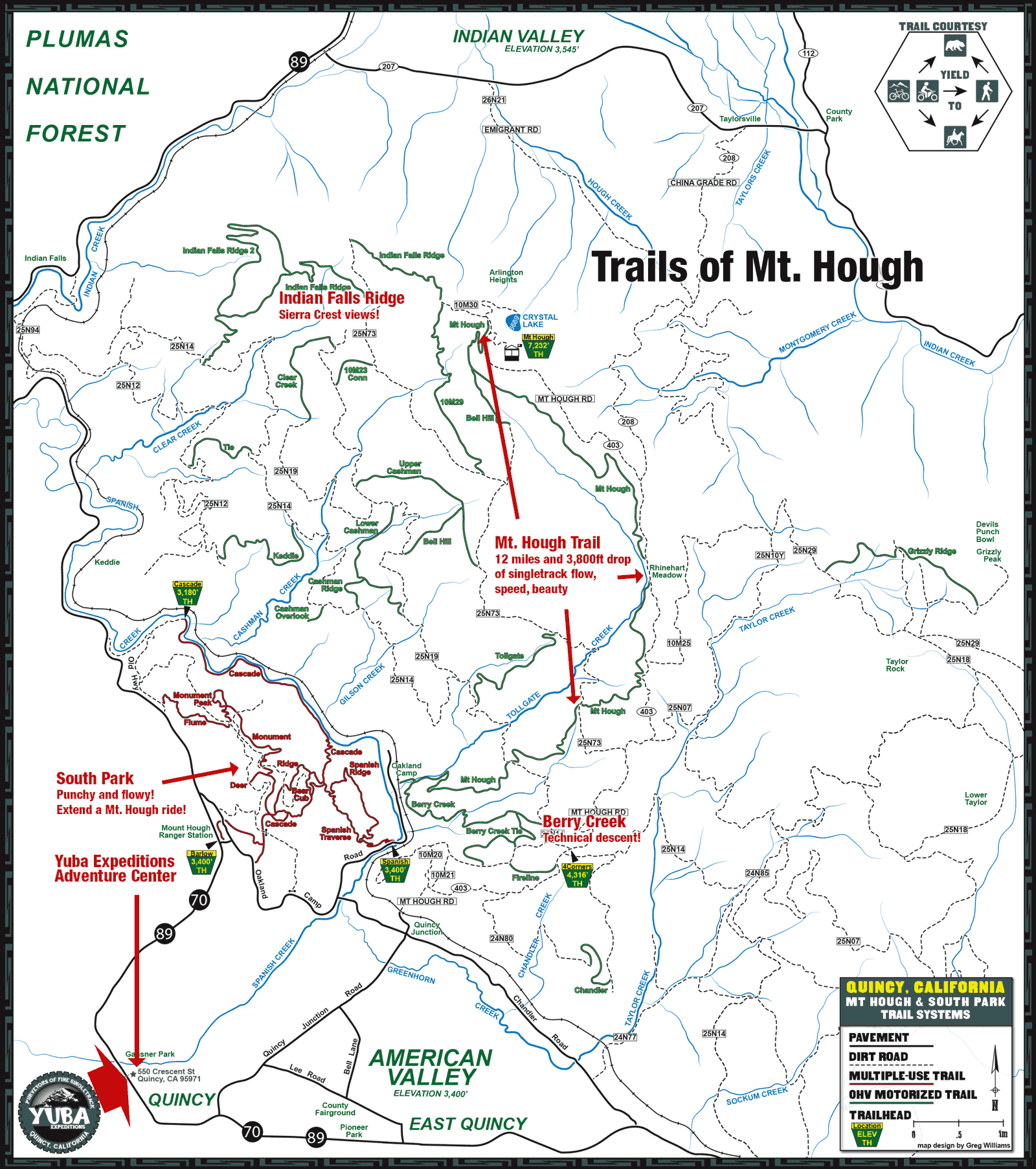
Mt. Hough Trails in Quincy
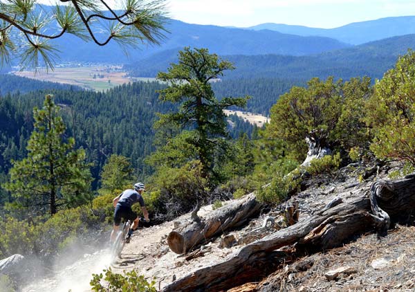
Completed in 2015 by our parent organization, the Sierra Buttes Trail Stewardship, the Mount Hough trail is 12 miles and 4000 vertical feet of singletrack flow, speed, beauty and amazing dirt (especially after some rain). Starting at 7,200 feet elevation above the emerald blue waters of Crystal Lake overlooking Genesee Valley, Mount Hough trail is fun for all ages and skill levels, featuring perfectly banked switchbacks, high-speed sections of trail with long sight lines, tabletop jumps for those who love air time and a perfect finish at a swimming hole on Spanish Creek. Mount Hough is in the Plumas National Forest and was built with California OHV funds,so it can also be ridden on a mountain bike, ebike or moto. Thanks to the National Forest Service and the SBTS Trail Crew the trail is back open and rideable after the damage from the Dixie fire in 2021. The trail winds in and out of the burn area providing an interesting and up close view of the post fire forest landscape.
Whether you shuttle with friends, shuttle with Yuba Expeditions or earn it the old fashioned way by pedaling, the best way to the top is by taking Mount Hough Road (bumpy dirt road passable by car in summer months) from Quincy Junction/Chandler Road all the to the top. At the bottom of the singletrack at Oakland Camp, after crossing the railroad tracks, keep heading downhill on pavement to the swimming hole before the bridge over Spanish Creek on Oakland Camp Road, which is a great place to start and finish from.
Mt. Hough on Trailforks.com
Trail Conditions
Quincy Area Trails
Mount Hough
Mount Hough trail is 12 miles and 4000 vertical feet of singletrack flow, speed, beauty and amazing dirt (especially after some rain). Starting at 7,200 feet elevation above the emerald blue waters of Crystal Lake overlooking Genesee Valley, Mount Hough trail is fun for all ages and skill levels, featuring perfectly banked switchbacks, high-speed sections of trail with long sight lines, tabletop jumps for those who love air time and a perfect finish at a swimming hole on Spanish Creek. Mount Hough is in the Plumas National Forest and was built with California OHV funds,so it can also be ridden on a mountain bike, ebike or moto. Thanks to the National Forest Service and the SBTS Trail Crew the trail is back open and rideable after the damage from the Dixie fire in 2021. The trail winds in and out of the burn area providing an interesting and up close view of the post fire forest landscape.as built with California OHV funds, it can also be ridden on an ebike. This is the ride to do.
Berry Creek
Need more a more technical trail experience on Mt. Hough? This is it. Old school moto trail. Starts down a fun manzanita corridor with playful woops then turns into a more technical narrow singletrack with loamy corners and high speed sidehilling. Finishes on an old roadbed at the base of the Mount Hough Trail, then crosses Tollgate Creek to Oakland Camp. In spring of 2022 the SBTS Trail Crew built a connector trail from Berry Creek Trail to Mt. Hough access road, so now you have more singletrack to choose from when riding lower Hough loops and when you do not want to get wet crossing the creek at the bottom of the Hough Trail.
Indian Falls Ridge
Amazing views, sculpted berms, and interesting rocky features make this one not to be missed. Ride it as an out and back from the top of Mt. Hough, down to Quarry Rd. or make a left on the 25N14 and ride back to Four Corners.
Indian Falls Ridge 2 (IFR2)
Nice option off of Indian Falls Ridge.
North Tollgate
Singletrack that follows an old roadbed with fun berms. Use this as a climb to get up Hough if you don’t want to take the dusty road or the usual downhill. New for Spring 2022 the Trail Crew is working on extending the trail down to Berry Creek trail doubling the length of the trail.
Chandler Trail
This loop trail starts and finishes at Four Corners (25N14/403) intersection. A mostly cross country trail with several naturally technical rock features, this trail makes a great add-on to a shuttle run from the top of Mt. Hough or as part of several ride options from Four Corners. The loop is 4.8 miles long and you can choose to stay on singletrack and climb the switchbacks, or go out to the road and spin back up to the start.
South Park
Super fun cross country area at the base of Mt. Hough between Spanish Creek and Chandler Road. South Park has punchy climbs and fast flowy descents through manzanita and oak corridors. The shaded Cascade Trail meanders along Spanish Creek past huge doug firs and several nice swimming holes. It also crosses two bridges that pass above Class V rapids. A great riding area for families with lots of interconnected trails and a few techy rock sections and skinny off camber sections. With a little something for every ability level and the fact that it is rideable almost year round South Park is a highly recommended zone to explore.
Bucks Creek Loop (near Bucks Lake Wilderness)
Chill 3.5mi loop through alpine meadows and mature doug fir and
cedar forests near Bucks Lake. Start from Bucks Summit down the south side of the loop and return to your car on the north side of the
loop. Or start from the Mill Creek trail head and ride up the North side of the loop and down the south side of the loop. Don’t
forget to stop at the Lakeshore Resort for wood fired pizza and cold drinks on Bucks Lake.
Mill Creek Trail (near Bucks Lake Wilderness)
Mellow out-and-back along Bucks Lake with great swimming opportunities.
Gravel Rides
Waiting for the snow to melt to access these high alpine gravel rides:
- Mt Hough
- Grinduro course sections
- Grizzly ridge trails
- Connections to taylorsville, Antelope Lake, Lake Davis
- Claremont
- Snake Lake
- Butterfly Valley
- Indian Valley
- Round Lake Reservoir
- Butt Reservoir
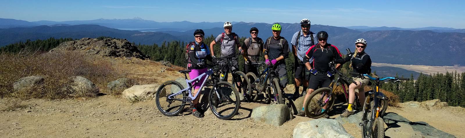
Top of Mt.Hough at 7,200ft with Mt. Lassen in the background.
Yuba Expeditions Builds and Maintains These Trails
Yuba Expeditions is owned and managed by Sierra Buttes Trail Stewardship. The proceeds from Yuba Expeditions go directly back into building and maintaining these trails. By taking our shuttle, or purchasing product from the shop, you are supporting the trails we all enjoy.
These trails are maintained by the Sierra Buttes Trail Stewardship in partnership with the Forest Service and other volunteer trail groups. Many of these trails are maintained as part of the Adopt-a-Trail Program administered and organized through the Sierra Buttes Trail Stewardship. The trail adoption program ensures that each individual trail receive regular maintenance and upkeep, each season.
The Stewardship also hosts monthly Trail Daze volunteer work days, these work days account for more than 30,000 volunteer labor hours on historic, multiple-use, and motorized multiple-use trails. If you enjoy riding high country trails in the Sierra Buttes region, then join us; as a volunteer, as a member, as a steward.